Contents
Overview
The roots of maritime surveillance stretch back millennia, long before the advent of electronic sensors. Ancient civilizations employed lookouts on shorelines and at sea, using signal fires and flags to communicate warnings and track approaching vessels. The development of the telescope in the 17th century significantly enhanced visual range, allowing for earlier detection of ships. During wartime, naval powers established elaborate coastal defense networks and employed reconnaissance ships. The 20th century brought revolutionary changes with the introduction of radar, which enabled detection of ships and aircraft regardless of visibility conditions. This era also saw the rise of aerial reconnaissance, with aircraft becoming vital tools for patrolling vast ocean areas. The Cold War spurred further advancements in sensor technology and data processing, laying the groundwork for modern, integrated surveillance systems. The establishment of the UN Convention on the Law of the Sea in 1982 further codified the need for states to monitor their extensive maritime zones, driving investment in surveillance capabilities worldwide.
⚙️ How It Works
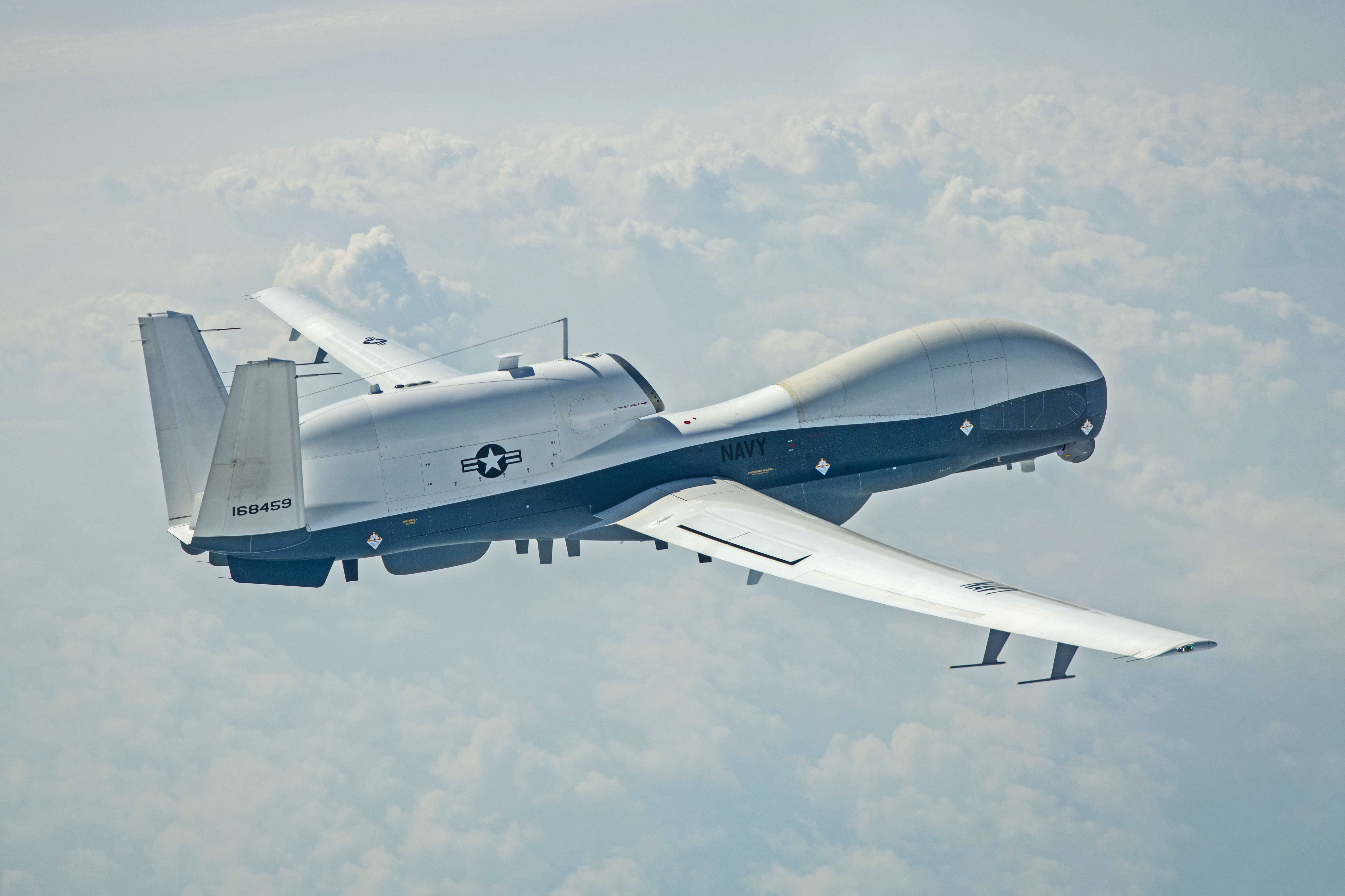
Modern maritime surveillance relies on a multi-layered approach, integrating data from a diverse range of platforms and sensors. Radar systems, both ground-based and shipborne, detect vessels by emitting radio waves and analyzing the reflected signals, providing range, bearing, and speed. Optical and infrared sensors mounted on aircraft, drones, and satellites capture visual and thermal imagery, enabling identification of vessel types and activities, even at night or through atmospheric haze. Automatic Identification System (AIS) transponders, mandatory for most commercial vessels, broadcast identification, position, and course information, which can be intercepted by shore stations or satellites. Signals intelligence (SIGINT) intercepts electronic emissions from vessels, providing further clues about their operations. Increasingly, artificial intelligence (AI) and machine learning (ML) are employed to process the massive influx of data, automatically identifying anomalies, tracking targets, and predicting potential threats. Unmanned aerial vehicles (UAVs), such as the MQ-4C Triton, offer persistent, long-endurance surveillance over vast areas, complementing traditional manned platforms like the P-8 Poseidon maritime patrol aircraft.
📊 Key Facts & Numbers
The global maritime domain is immense. Over 90% of global trade by volume is transported by sea, making the monitoring of shipping lanes crucial for economic stability. The global maritime surveillance market was valued at approximately $15 billion in 2023 and is projected to grow to over $25 billion by 2030, reflecting increasing demand. The International Maritime Organization (IMO) mandates Automatic Identification System (AIS) for vessels over 300 gross tons on international voyages. The United States Coast Guard operates a network of over 100 radar sites and utilizes numerous aerial and maritime assets for its surveillance missions. Satellite-based maritime surveillance, utilizing constellations like ESA's Sentinel-1 and Maxar's commercial imagery, provides global coverage.
👥 Key People & Organizations
Key organizations driving maritime surveillance include national navies and coast guards, such as the United States Navy, Royal Navy, and China Coast Guard. International bodies like the International Maritime Organization (IMO) set standards and regulations. Technology developers are central to advancements, with companies like Lockheed Martin, Raytheon Technologies, and Thales Group producing sophisticated radar, sonar, and sensor systems. Northrop Grumman is a major player in UAV development for maritime roles, exemplified by the MQ-4C Triton. Satellite imagery providers like Maxar Technologies and Airbus Defence and Space offer crucial overhead perspectives. Research institutions and universities, such as the Massachusetts Institute of Technology (MIT) and the UK's National Oceanography Centre, contribute to fundamental research in sensor technology and data analysis. Global Fishing Watch is a notable non-profit organization leveraging technology to monitor and promote sustainable fishing practices through vessel tracking.
🌍 Cultural Impact & Influence
Maritime surveillance has profoundly shaped global security and economic interactions. It underpins the enforcement of international law at sea, enabling the interdiction of illegal activities such as piracy, drug trafficking, and illegal, unreported, and unregulated (IUU) fishing. The ability to monitor shipping traffic is fundamental to naval strategy and power projection, influencing geopolitical dynamics. Environmental awareness has also been heightened, with surveillance systems used to detect oil spills, monitor marine pollution, and track the impact of climate change on ocean ecosystems. The development of maritime surveillance technologies has also spurred innovation in related fields, including remote sensing, data fusion, and cybersecurity, creating a ripple effect across various industries. Public awareness of maritime issues, from environmental protection to territorial disputes, is often informed by imagery and data derived from these surveillance efforts.
⚡ Current State & Latest Developments
The current landscape of maritime surveillance is characterized by rapid technological integration and an increasing focus on persistent, wide-area monitoring. The deployment of artificial intelligence (AI) for automated target recognition and anomaly detection is a major trend, allowing human operators to focus on higher-level analysis rather than sifting through raw data. The proliferation of unmanned aerial vehicles (UAVs) and unmanned surface vehicles (USVs) is expanding surveillance capabilities, offering cost-effective and persistent monitoring solutions. Satellite constellations are growing in number and capability, providing higher resolution imagery and more frequent revisits. There's a significant push towards sensor fusion, integrating data from disparate sources (radar, AIS, electro-optical, SIGINT) into a unified operational picture. The North Atlantic Treaty Organization (NATO) is actively investing in advanced maritime surveillance capabilities to counter emerging threats. Furthermore, the increasing use of commercial satellite data and open-source intelligence is democratizing access to maritime awareness, though it also presents challenges in verification and attribution.
🤔 Controversies & Debates
Maritime surveillance is not without its controversies and debates. The extensive use of surveillance technologies raises significant privacy concerns, particularly regarding the tracking of commercial and private vessels. The potential for misuse of surveillance data, whether for economic espionage or political leverage, is a constant worry. The development and deployment of advanced autonomous surveillance systems, like unmanned aerial vehicles (UAVs), also spark debate about accountability and the ethics of remote warfare or enforcement. There are ongoing discussions about the balance between national security requirements and the freedom of navigation. Furthermore, the cost of implementing and maintaining sophisticated maritime surveillance systems can be prohibitive for many nations, leading to disparities in capability and potentially exacerbating existing power imbalances. The effectiveness of certain technologies, such as AIS, is also debated, as signals can be spoofed or turned off, leading to blind spots.
🔮 Future Outlook & Predictions
The future of maritime surveillance points towards increasingly autonomous,
Key Facts
- Category
- technology
- Type
- topic